- The previous La Niña in 2020 was the first-ever “triple dip” recorded, taking place three years in a row rather than once every two to seven years.
- The El Niño earlier this year means there is an over 70 per cent chance the La Niña will occur again this year.
- The La Niña phenomenon increases the risk of those rare “once-in-100 years” flood disasters.
KUALA LUMPUR, Aug 27 — The climate phenomenon that left Malaysia sweltering in an atypical midyear heatwave could soon subside, but experts warn that this may be replaced by another that could have the country bracing for potentially worse floods.
Last month is already confirmed as the hottest July ever on record, leaving parts of the world including in Malaysia on the verge of drought.
But the relief any rainfall will bring might come with despair, as the Malaysian Meteorological Department (MetMalaysia) told Malay Mail that the monsoon winds have been inactive compared to previous years, indicating that the country could see heavier than usual rainfall.
“Since the monsoon winds have not been very active since last week, it is found that many areas have received rains, causing the maximum temperature to be in the normal reading between 32 and 34°C,” said MetMalaysia Deputy Director-General (Operations) Mohd Hisham Mohd Anip.
“At the same time, there is no formation of tropical cyclones either in the South China Sea or in the western Pacific Ocean which would normally affect the weather in the country’s region to make it drier and warmer,” he added.
He said that the persisting trend should lead to rain patterns developing this month.
Renard Siew, a specialist in sustainability and climate change, explained that this transition is not just the move into the annual southwest monsoon period, but part of a La Niña that occurs once every two to seven years.
“We are now going through a transition to La Niña, a climate pattern that is part of the larger Southern Oscillation cycle. It is characterised by cooler-than-average sea surface temperatures in the central and eastern Pacific Ocean, which contrasts with the warmer-than-average conditions observed during El Niño events.
“This is where we can expect wetter seasons and thunderstorms. The climate crisis is exacerbating extreme weather events not just prolonged droughts but also floods. So the likelihood of floods happening at hotspot areas is higher,” he said.

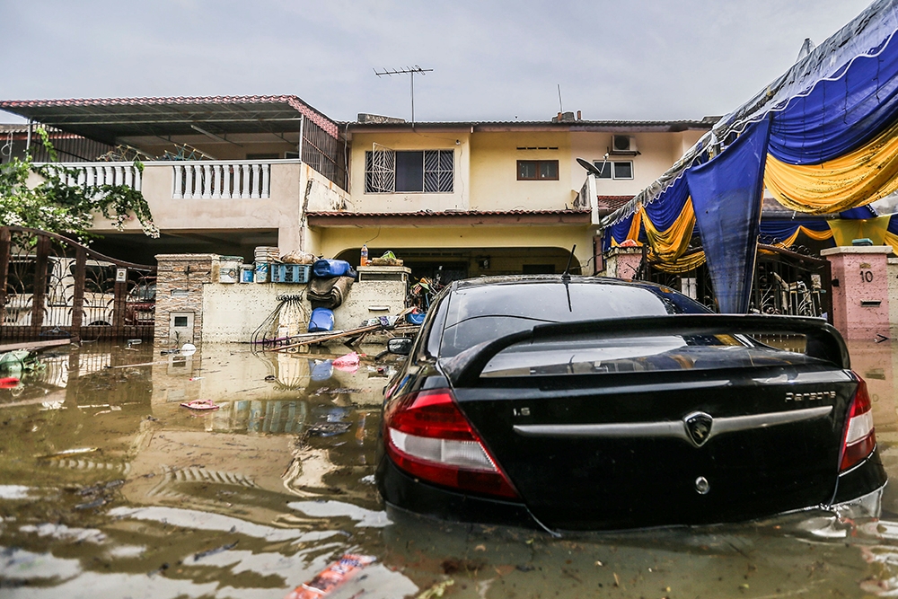
A file photograph shows homes inundated by floodwaters in Taman Sri Muda in Shah Alam on December 20, 2021. — Picture by Hari Anggara
The previous La Niña was also the first ever “triple dip” La Niña to ever be recorded, and lasted three consecutive years instead of the usual pattern of just several months.
Prof Datuk Azizan Abu Samah from the National Antarctica Research Centre said there is a 79 per cent chance Malaysia will experience La Niña by the end of the year.
“We need to monitor if it is forecasted to be a strong or weak La Niña. If it’s a strong La Niña, we may have 10 to 20 per cent more rain and higher risk of major flooding during the early part of the Northeast Monsoon November to December for the east coast,” he said.
Chairman of Earth and Environmental Sciences Department at Universiti Kebangsaan Malaysia, Prof Fredolin Tangang said that while no model could accurately predict the likelihood and severity of weather phenomena, the El Niño pattern that occurred earlier this year made the La Nina counterpattern probable by next month.
However, he said previous climate disasters indicate that Malaysia must be prepared for the worst.
“The worst flood we experienced at the end of 2021 in Selangor and Kuala Lumpur occurred during a La Niña year. It was actually caused by a tropical depression system that developed over the southern part of the South China Sea and propagated westward towards Terengganu and Pahang and caused flooding there.
“Usually, the system dies out once it over land over the peninsula and less likely affecting the west coast. However, what was exceptional for that system in the 2021 flood was that the remnant of the tropical system managed to cross over land and it strengthened when it was over the Straits of Malacca. The warm water over the Straits of Malacca re-energised the system causing massive flooding over Selangor and Kuala Lumpur.
“This is a rare event, could be one-in-100 years but the risk increases when we have a La Niña during the northeast monsoon,” he said.

